


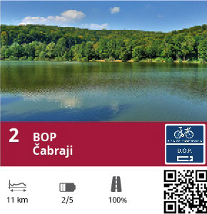
Lake Route – Čabraji
Track info
| Track lenght: | 10,53 km |
| Time needed: | 0:31:00 |
| Height start: | 143 m |
| Height finish: | 162 m |
| The sum of vertical ascent: | 100 m |
| The maximum point of the track: | 170 m |
| Track difficulty: | Medium |
| Terrain type: | asphalt |
| Bike type: | Road bike |
Description of track
The route starts from the centre of Križevci, passes the avenue of trees in the Upper Town, and before the cemetery turns right in the direction of Apatovac, known as the source of Kalnik mineral water. After a short climb to Ivanac Križevački, the route turns right toward Čabraji. In the town itself a left turn leads to the lake. On the right-hand side of the route is Village Tourism “Rakić,” which on weekends and by appointment offer a rich selection of domestic food. Lake Čabraji covers about eight hectares and is a real magnet for tourists desiring peace, fishing and long walks in the unspoiled nature. The lake shore is ideal for camping, while the forest close to the lake guarantees intimacy and seclusion.


